Posted 30/5/09
Geological specialists and environment and heritage organisations have warned the Victorian Government that a proposed development on Port Campbell’s headland is high risk and may accelerate the collapse of the unstable sea caverned headland. Crown land and national park containing significant Indigenous and European cultural heritage and rare heathland will be lost. In what appears to be a massive liability risk, the development, the 129-year-old port, and possibly the township itself, will be unviable if this headland collapses.
Port Campbell’s spectacular limestone cliffs are part of the world-renowned Port Campbell National Park, a major Australian tourist icon. The collapse of one of the Twelve Apostles in 2005 made national and international headlines.
:
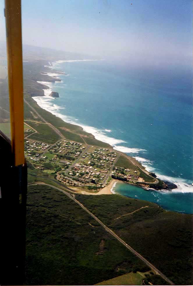
Aerial view of Port Campbell looking towards the Twelve Apostles
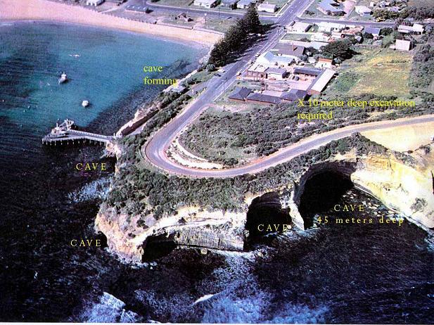
The four major sea caverns in Port Campbell headland are a perfect example of the natural processes involved in the formation of rock stacks (see diagram compliments Dr Eric Bird). The headland is clearly a fragile site.
Port Campbell headland before the Great Ocean Road closure in 2003
Yet a 10m deep excavation, for the proposed Southern Ocean Beach House which has been approved by VCAT, would be very close to these caverns which VicRoads has reported may collapse at any time. The Great Ocean Road on the headland was closed in 2003 due to the high risk of sea cavern collapse. The development requires further unstable Crown land on the headland, Public Park War Memorial Reserve, for buses accessing its reception area. Any extension of the roadway will take the development’s tourist coaches close to the sea caverns. When the headland collapses, the road would have to run through the ‘Beach House’ area.
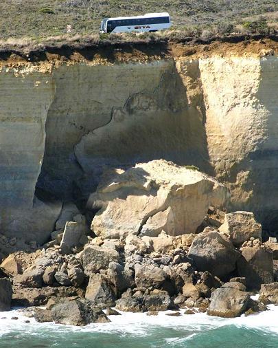
Nearby cliff fall
The development was to cater for tourism, but now an application has been sought to subdivide into apartments.
The proposal’s 100m frontage would take up over a third of the Port Campbell foreshore and double the number of shops in the town. Its 4 storeys would block public viewlines to and from the national park. Its 97 apartments (130 rooms), ten shops and 200-seat restaurant would equal the number of accommodation rooms and shops at Lorne’s large Cumberland resort.
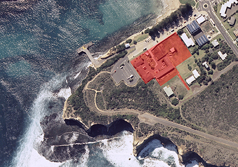
Proposed development site (red overlay)
Port Campbell’s small community is wondering why the Government appears to be ignoring a potentially catastrophic scenario.
A Parliamentary Select Committee on Public Land Development found that the Southern Ocean Beach House would “have significant visual impacts and may have serious geological stability and public safety impacts on the surrounding area. Evidence suggests the proposal may not conform to the local planning scheme that aims to preserve the low rise and village character of the Port Campbell township”.
The Committee noted the “lack of cultural, social and heritage assessment before the Department of Sustainability and Environment consent for use and development of Crown land (Public Park War Memorial Reserve) should be revised”.
It recommended a geotechnical assessment of the headland’s stability, which was carried out, but geo-specialists have advised the Government that this assessment was superficial and had major flaws which could compromise public safety and the public and private assets of the headland. They have also asked why the assessment seems to ignore relevant references and was so limited as to have no credibility.
What will be lost?
The Aboriginals called Port Campbell Purroitchihoorrong, ‘the spirit voice that mocks you’. It is believed this name refers to the echo that can be heard outside the largest sea cavern, which can only be accessed at rare low tides, or to the thunderous echo and rumble of the huge Southern Ocean swells that crash into the cave. In 1969 Aldo Massola recorded an Aboriginal camp site on the headland (Point Sturgess), and adjoining this there are narrow Aboriginal steps cut into the coastal cliff to access the reef.
Port Campbell is central to the Shipwreck Coast. The port was developed in response to Australia’s most famous shipwreck, the Loch Ard disaster (1878), and it remains the only access point for that and many other heritage shipwrecks. The port is also the only access point for boats going to the Twelve Apostles Marine National Park and The Arches Marine Sanctuary, and it has been used for the recent development of the nearby Geographe and Thylacine offshore gas-fields.
The port, which has a unique T-shaped jetty that directly fronts the Southern Ocean, retains its original form and function. It is the only Victorian port where boats are winched in and out of the water to protect them from the often treacherous ocean swells. But if the headland falls, the sheltered port will be opened to sea attack, much of the town’s natural and maritime heritage will be lost, and the town itself will be at risk of storm attack and sea inundation.
The headland has a significant remnant of endangered coastal heathland and coastal tussock vegetation. It supports the Metallic Sun Orchid Thelymitra epipactoides. Southern Brown Bandicoots are occasionally seen, and Echidnas abound. Complementing the roar of the waves, the headland resounds with the melodic whistles of a prolific population of Rufous Bristlebirds. The area is also on the migratory path of the nationally significant Orange-bellied Parrot, and Peregrine Falcons and Nankeen Kestrels are frequently observed hunting on the cliffs and headland Before the introduction of helicopter joy flights along the coast, other significant birds, including several albatross and petrel species and the occasional White-bellied Sea-eagle, could be seen from the headland.
The bay’s role as a habitat of the Southern Right Whale underlines its importance as a natural reserve. Killer and Blue Whales are also sited from the headland.
Port Campbell folk are generally tough, hardy people, but like their rugged environment which is crumbling into the sea they are feeling the strain of development pressure, and many fear that the essence, the environmental and cultural heritage, of their home is about to be lost to over scale development which threatens the local and state planning policies to ‘retain the low scale coastal village character’.
The National Trust has recently listed the headland features as of State significance, following a Port Campbell Community Group Inc. submission.
The Group is also waiting to hear from Aboriginal Affairs Victoria following an Aboriginal Heritage Nomination. Port Campbell National Park is on the register of the National Estate (place ID: 3778).
The community has asked the Government to refuse to re-issue the consent for use and development of Crown land as the Southern Ocean Beach House appears to be overdeveloping its fragile site.
Townspeople are hoping that logic will prevail and the Government will stop the proposed high-risk excavation, and not permit any more environmentally sensitive land to be developed. Significant State and National heritage is at risk.
Port Campbell Community Group Contact:
Marion Manifold
Secretary
Port Campbell Community Group Inc. A0051688U
mmanifold@ansonic.com.au
What you can do
Write to Premier John Brumby and Hon Ministers Justin Madden and Gavin Jennings and ask that the Government conducts a full cultural, social and heritage assessment before any consent for use and development of Crown land (Public Park War Memorial Reserve), and that the development should be modified to limit its excavation in such a fragile site.
Write to Hon John Brumby, Premier of Victoria, 1 Treasury Place, East Melbourne, Vic. 3002. T: 9651 5000;
Email:
john.brumby@parliament.vic.gov.au;
justin.madden@parliament.vic.gov.au;
gavin.jennings@parliament.vic.gov.au